SOURCE: Breaking Israel News
DATE: June 26, 2020
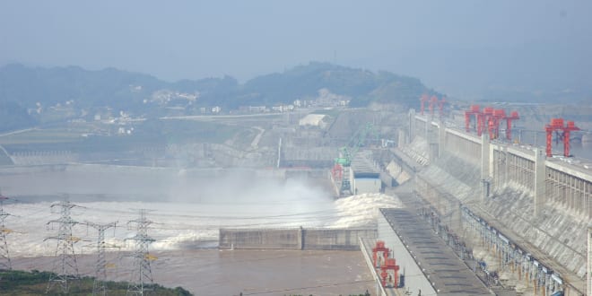
SNIP: Weeks of heavy rain have put the Three Gorges Dam, the largest hydropower project in the world, in danger of collapse putting 400 million people at risk. The flooding has been described as the worst since 1949 with natural disasters being declared in 24 provinces and municipalities in the southwest and central China, especially in areas near the upper reaches of the Yangtze River and the Three Gorges Dam, causing the reservoir’s water level to exceed the flood control line.
The water level in China’s massive Three Gorges Reservoir reached 147 meters on Saturday, two meters above the flood warning line. Meanwhile, the inflow increased to 26,500 cubic meters per second from 20,500 cubic meters per second on the previous day.
An estimated 400 million people live downstream of the Three Gorges Dam. The Ministry of Water Resources said that 148 rivers had exceeded warning levels. For the first time in history the Chongqing section of the Qijiang River Basin issued a red warning, signifying a flood of more than 10 meters. More than 40,000 people have so far been evacuated.
Made of concrete and steel, the dam is 7,661 feet long and the concrete dam wall is 594 feet high above the rock basis. The dam caused considerable controversy when it was built, displacing over a million people and submerging large areas of the Qutang, Wu and Xiling gorges for about 600km. The dam flooded archaeological and cultural sites and caused significant ecological changes including an increased risk of landslides. The dam has been controversial both domestically and abroad –while creating a deep reservoir that ocean-going freighters can navigate for 2,250km inland from Shanghai on the East China Sea to the inland city of Chongqing.
Days after the first filling of the reservoir, around 80 hairline cracks were observed in the dam’s structure. It was determined that the submerged spillway gates of the dam might pose a risk of cavitation. In addition, the dam sits on a seismic fault. At current levels, 80% of the land in the area is experiencing erosion. In 2010, NASA scientists calculated that the shift of water mass stored by the dams would increase the length of the Earth’s day by 0.06 microseconds and make the Earth slightly more round in the middle and flat on the poles.
In July 2019, a satellite image of Google Maps appeared to show that the Three Gorges Dam was distorted, sparking concerns that it is at the edge of breaking.